INES Ontology
- This version:
- https://datos.iepnb.es/def/sector-publico/medio-ambiente/ines/1.0
- Latest version:
- https://datos.iepnb.es/def/sector-publico/medio-ambiente/ines#
- Revision:
- 1.0
- Authors:
- Tragsatec (Grupo Tragsa)
- Download serialization:


- License:

- Visualization:

- Cite as:
- Tragsatec. INES Ontology. Revision: 1.0. Retrieved from: https://datos.iepnb.es/def/sector-publico/medio-ambiente/ines/1.0
Abstract
An RDF/OWL vocabulary to represent spatial information on soil erosion according to the spanish National Soil Erosion Inventory (INES, in spanish).Introduction back to ToC
This vocabulary is used to represent the minimum knowledge available in the INES information system, but facilitating the formalisation and integration of the data domain with larger and more consensual ontologies. For this purpose, various ontological resources such as the Spatial Mesh, GeoSPARQL, DCAT, OWL-Time, Event, PROV and FraPPE vocabularies are reused.
Namespace declarations
| ines | <https://datos.iepnb.es/def/sector-publico/medio-ambiente/ines#> |
| qudt | <http://qudt.org/schema/qudt#> |
| owl | <http://www.w3.org/2002/07/owl#> |
| skos | <http://www.w3.org/2004/02/skos/core#> |
| terms | <http://purl.org/dc/terms#> |
| geo-core | <https://datos.ign.es/def/geo_core#> |
| event-owl | <http://purl.org/NET/c4dm/event.owl#> |
| vann | <http://purl.org/vocab/vann#> |
| ontology | <http://www.geonames.org/ontology#> |
| ontodebug | <http://ainf.aau.at/ontodebug#> |
| vaem | <http://www.linkedmodel.org/schema/vaem#> |
| dtype | <http://www.linkedmodel.org/schema/dtype#> |
| frappe | <http://streamreasoning.org/ontologies/frappe#> |
| geosparql | <http://www.opengis.net/ont/geosparql#> |
| unit | <http://qudt.org/vocab/unit#> |
| sector-publico | <http://vocab.linkeddata.es/datosabiertos/def/sector-publico#> |
| schema | <http://qudt.org/2.1/schema#> |
| code | <http://publications.europa.eu/resource/authority/nuts/code#> |
| btn100 | <https://datos.ign.es/def/btn100#> |
| ns | <http://www.w3.org/2006/vcard/ns#> |
| xsd | <http://www.w3.org/2001/XMLSchema#> |
| rdfs | <http://www.w3.org/2000/01/rdf-schema#> |
| sf | <http://www.opengis.net/ont/sf#> |
| vocab | <http://qudt.org/2.1/vocab#> |
| geonames | <http://www.geonames.org#> |
| dcat | <http://www.w3.org/ns/dcat#> |
| prov | <http://www.w3.org/ns/prov#> |
| territorio | <http://vocab.linkeddata.es/datosabiertos/def/sector-publico/territorio#> |
| malla-espacial | <https://datos.iepnb.es/def/sector-publico/territorio/malla-espacial#> |
| ont | <http://www.opengis.net/ont#> |
| rdf | <http://www.w3.org/1999/02/22-rdf-syntax-ns#> |
| time | <http://www.w3.org/2006/time#> |
| dc | <http://purl.org/dc/elements/1.1#> |
INES Ontology: Overview back to ToC
This ontology has the following classes and properties.Classes
- area unit
- base unit
- Capture
- CapturedFrame
- carcavas y barrancos categoria
- carcavas y barrancos valor
- catalog
- categoria
- celda
- centroide
- Ciudad Autónoma
- collection
- Comunidad Autónoma
- Comunidad Jurisdiccional
- concept
- concept scheme
- Curve
- data service
- dataset
- Derived Unit
- distribution
- en cauces categoria
- en cauces valor
- entity
- eolica categoria
- eolica valor
- Feature Feature
- Frame
- Geometry
- Geometry Collection
- Geometry Geometry
- Instante
- Intervalo
- kind
- laminar y regueros valor
- license document
- Line
- Line String
- Linear Ring
- linguistic system
- location
- Lugar
- malla
- MarcoCapturado ErosionCarcavasYBarrancos
- MarcoCapturado ErosionEnCauces
- MarcoCapturado ErosionEolica
- MarcoCapturado ErosionLaminarYRegueros
- MarcoCapturado ErosionMovimientosEnMasa
- media type or extent
- movimientos en masa categoria
- movimientos en masa valor
- Multi Curve
- Multi Line String
- Multi Point
- Multi Polygon
- Multi Surface
- Municipio
- Niveles erosivos de erosión laminar y en regueros
- objeto geografico
- País
- period of time
- Pixel
- Point
- Polygon
- Polyhedral Surface
- provenance statement
- Provincia
- Quantity
- Quantity Kind
- Quantity value
- QUDT Concept
- resource
- resource
- rights statement
- SpatialObject SpatialObject
- standard
- Surface
- Triangle
- Triangulated Irregular Network
- Unidad Administrativa
- Unit
- valor pixel
Object Properties
- access u r l
- capital
- centroide de
- conforms to
- contact point
- Contains
- contains
- contiene categoria
- dataset
- dcat:catalog
- dcat:dataset
- dcat:service
- default geometry
- distribution
- elevacion media
- endpoint u r l
- es capital de
- es geometria de
- format
- frappe:samplingTime
- generated
- had derivation
- had member
- has beginning
- has end
- has exact match
- has geometry
- has quantity
- has top concept
- in scheme
- isIn
- isla
- isLocationOf
- isReferredBy
- language
- license
- location
- malla de
- pertenece a la autonomía
- pertenece a provincia
- pertenece al municipio
- pertenece al país
- pertenecea celda
- pertenecea malla
- Pixel value belongs to Captured Frame
- provenance
- publisher
- quantity value
- refers
- rights
- spatial
- spatial reference system
- surface
- temporal
- The pixel value is in the Pixel/Cell.
- The pixel value is restricted by the Captured Frame.
- theme
- tiene celda
- tiene centroide
- tiene valor car bar
- tiene valor en cauces
- tiene valor eolica
- tiene valor lam reg
- tiene valor movi masa
- timeExposure
- top concept of
- top object property
- type
- unidad administrativa
- unit
- used
- valor car bar esta en pixel
- valor en cauces esta en pixel
- valor eolica esta en pixel
- valor lam reg esta en pixel
- valor movi masa esta en pixel
- was derived from
- was generated by
- was member of
- wasCapturedFrom
- wasSynthetizedFrom
- within
Data Properties
- asGML asGML
- asWKT asWKT
- code
- column
- conversion coefficient
- conversion multiplier
- conversion offset
- código de país ISO
- ended at time
- has categoria
- has serialization has serialization
- height
- keyword
- latex symbol
- literal
- literal
- row
- started at time
- symbol
- symbol token
- tiene valor pixel
- width
Named Individuals
- ActividadCapturada INES2015
- Area Area
- CarcavasYBarrancosCategoria:Enclave
- CarcavasYBarrancosCategoria:ZonaErosionCarcavas
- Categoria:LaminasDeAguaSuperficialesYHumedales
- Categoria:SuperficiesArtificiales
- ColeccionErosionSuelos INES
- EnCaucesCategoria:Alto
- EnCaucesCategoria:Bajo
- EnCaucesCategoria:Medio
- EnCaucesCategoria:MuyAlto
- EolicaCategoria:Alto
- EolicaCategoria:Bajo
- EolicaCategoria:Medio
- EolicaCategoria:MuyAlto
- EolicaCategoria:MuyBajo
- españa
- Fecha:2015-01-01
- LaminarYReguerosCategoria:<=5
- LaminarYReguerosCategoria:#100<=200
- LaminarYReguerosCategoria:#10<=25
- LaminarYReguerosCategoria:#200
- LaminarYReguerosCategoria:#25<=50
- LaminarYReguerosCategoria:#50<=100
- LaminarYReguerosCategoria:#5<=10
- Marco:INES2015
- MarcoCapturado:ErosionCarcavasYBarrancos2015
- MarcoCapturado:ErosionEnCauces2015
- MarcoCapturado:ErosionEolica2015
- MarcoCapturado:ErosionLaminarYEnRegueros2015
- MarcoCapturado:ErosionMovimientosEnMasa2015
- Meter meter
- MovimientosEnMasaCategoria:Alta
- MovimientosEnMasaCategoria:BajaOModerada
- MovimientosEnMasaCategoria:Media
- MovimientosEnMasaCategoria:MuyAlta
- MovimientosEnMasaCategoria:NulaOMuyBaja
- spatial reference system
- Square Meter square-meter
- ValorPixel:-9999
- ValorPixel:1
- ValorPixel:2
- ValorPixel:4
- ValorPixel:5
- ValorPixel:6
- ValorPixel:6
- ValorPixel:7
- ValorPixel:8
- ValorPixel:9
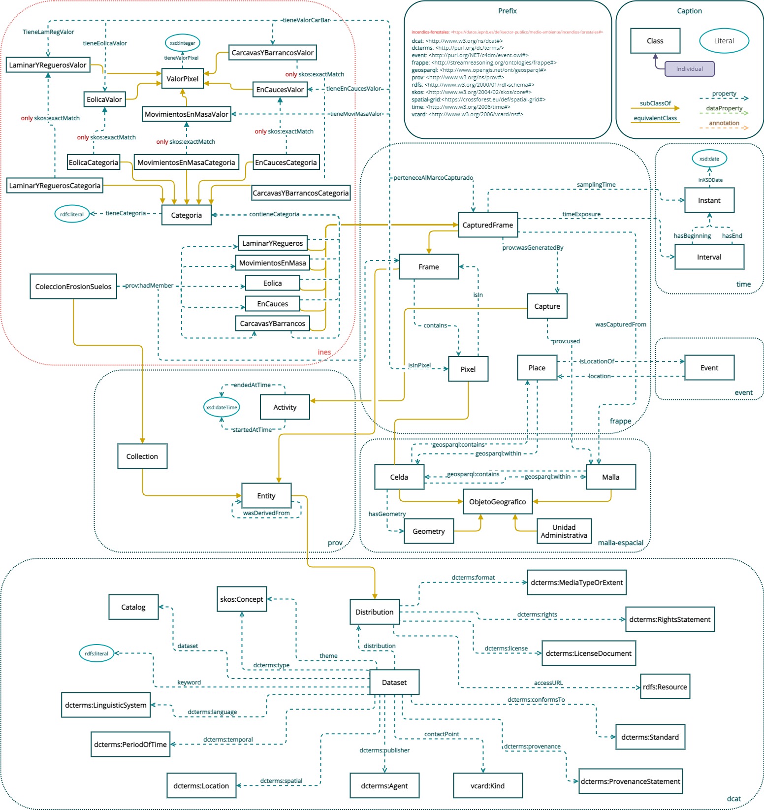
INES Ontology: Description back to ToC
The following model shows the internal structure of the ines ontology, as well as its relationship to external ontologies.
For all INES derived products, the size of the cell/pixel matrix is defined by the spatial resolution of the 25 m raster of the spatial grid of Spain, which is intended to be used as a reference. When the pixels contain classified values, the range of values to decode them must be provided; also, and since it is intended to evaluate continuously, the inventory is elaborated with a periodicity of 10 years and at a provincial scale, so all the products have a versioning.
In the interest of maintaining semantic coherence with standard vocabularies at a general level, the geosparql vocabularies for geometries and time have been adopted for the incorporation of temporal information. Standard vocabularies for the description of resources in the Spanish context are also included, such as the vocabulary for the representation of territory data (esadm) or that of the 25 meter spatial grid of Spain (malla-espacial).
Aditionally, a module is included to describe open data using the DCAT vocabulary recommended by the W3C. In order to ensure the description of the specific characteristics of open spatial data and compatibility with the implementing rules of the INSPIRE Directive GeoDCAT-AP has been adopted. The extension proposed by the European Commission for spatial data extends this profile by incorporating descriptors designed to ensure compatibility with the INSPIRE metadata regulation, and therefore allows a direct correspondence with the international standard ISO 19115 and ISO 19119.
Cross reference for INES Ontology classes, properties and dataproperties back to ToC
This section provides details for each class and property defined by INES Ontology.Classes
- area unit
- base unit
- Capture
- CapturedFrame
- carcavas y barrancos categoria
- carcavas y barrancos valor
- catalog
- categoria
- celda
- centroide
- Ciudad Autónoma
- collection
- Comunidad Autónoma
- Comunidad Jurisdiccional
- concept
- concept scheme
- Curve
- data service
- dataset
- Derived Unit
- distribution
- en cauces categoria
- en cauces valor
- entity
- eolica categoria
- eolica valor
- Feature Feature
- Frame
- Geometry
- Geometry Collection
- Geometry Geometry
- Instante
- Intervalo
- kind
- laminar y regueros valor
- license document
- Line
- Line String
- Linear Ring
- linguistic system
- location
- Lugar
- malla
- MarcoCapturado ErosionCarcavasYBarrancos
- MarcoCapturado ErosionEnCauces
- MarcoCapturado ErosionEolica
- MarcoCapturado ErosionLaminarYRegueros
- MarcoCapturado ErosionMovimientosEnMasa
- media type or extent
- movimientos en masa categoria
- movimientos en masa valor
- Multi Curve
- Multi Line String
- Multi Point
- Multi Polygon
- Multi Surface
- Municipio
- Niveles erosivos de erosión laminar y en regueros
- objeto geografico
- País
- period of time
- Pixel
- Point
- Polygon
- Polyhedral Surface
- provenance statement
- Provincia
- Quantity
- Quantity Kind
- Quantity value
- QUDT Concept
- resource
- resource
- rights statement
- SpatialObject SpatialObject
- standard
- Surface
- Triangle
- Triangulated Irregular Network
- Unidad Administrativa
- Unit
- valor pixel
area unitc back to ToC or Class ToC
IRI: http://qudt.org/schema/qudt/AreaUnit
- has super-classes
- Unit c
- has members
- Square Meter square-meter ni
base unitc back to ToC or Class ToC
IRI: http://qudt.org/schema/qudt/BaseUnit
- has super-classes
- Unit c
- has members
- Meter meter ni
- is disjoint with
- Derived Unit c
Capturec back to ToC or Class ToC
IRI: http://streamreasoning.org/ontologies/frappe#Capture
- Is defined by
- https://datos.iepnb.es/def/sector-publico/medio-ambiente/ines#
- https://datos.iepnb.es/def/sector-publico/medio-ambiente/ines#
- has super-classes
- activity c
- is in domain of
- used op
- has members
- ActividadCapturada INES2015 ni
CapturedFramec back to ToC or Class ToC
IRI: http://streamreasoning.org/ontologies/frappe#CapturedFrame
- Is defined by
- https://datos.iepnb.es/def/sector-publico/medio-ambiente/ines#
- https://datos.iepnb.es/def/sector-publico/medio-ambiente/ines#
- has super-classes
- Frame c
- has sub-classes
- MarcoCapturado ErosionCarcavasYBarrancos c, MarcoCapturado ErosionEnCauces c, MarcoCapturado ErosionEolica c, MarcoCapturado ErosionLaminarYRegueros c, MarcoCapturado ErosionMovimientosEnMasa c
- is in domain of
- frappe:samplingTime op, timeExposure op, wasCapturedFrom op
- is in range of
- Pixel value belongs to Captured Frame op, The pixel value is restricted by the Captured Frame. op
- has members
- MarcoCapturado:ErosionCarcavasYBarrancos2015 ni, MarcoCapturado:ErosionEnCauces2015 ni, MarcoCapturado:ErosionEolica2015 ni, MarcoCapturado:ErosionLaminarYEnRegueros2015 ni, MarcoCapturado:ErosionMovimientosEnMasa2015 ni
carcavas y barrancos categoriac back to ToC or Class ToC
IRI: https://datos.iepnb.es/def/sector-publico/medio-ambiente/ines#CarcavasYBarrancosCategoria
- has super-classes
- categoria c
- has members
- CarcavasYBarrancosCategoria:Enclave ni, CarcavasYBarrancosCategoria:ZonaErosionCarcavas ni
carcavas y barrancos valorc back to ToC or Class ToC
IRI: https://datos.iepnb.es/def/sector-publico/medio-ambiente/ines#CarcavasYBarrancosValor
- has super-classes
- valor pixel c
- is in domain of
- valor car bar esta en pixel op
- is in range of
- tiene valor car bar op
catalogc back to ToC or Class ToC
IRI: http://www.w3.org/ns/dcat#Catalog
- has super-classes
- dataset c
- is in domain of
- dcat:catalog op, dcat:dataset op, dcat:service op
- is in range of
- dcat:catalog op
categoriac back to ToC or Class ToC
IRI: https://datos.iepnb.es/def/sector-publico/medio-ambiente/ines#Categoria
- has sub-classes
- Niveles erosivos de erosión laminar y en regueros c, carcavas y barrancos categoria c, en cauces categoria c, eolica categoria c, movimientos en masa categoria c
- is in domain of
- contiene categoria op, has categoria dp
- is in range of
- contiene categoria op
- has members
- CarcavasYBarrancosCategoria:Enclave ni, CarcavasYBarrancosCategoria:ZonaErosionCarcavas ni, Categoria:LaminasDeAguaSuperficialesYHumedales ni, Categoria:SuperficiesArtificiales ni, EnCaucesCategoria:Alto ni, EnCaucesCategoria:Bajo ni, EnCaucesCategoria:Medio ni, EnCaucesCategoria:MuyAlto ni, EolicaCategoria:Alto ni, EolicaCategoria:Bajo ni, EolicaCategoria:Medio ni, EolicaCategoria:MuyAlto ni, EolicaCategoria:MuyBajo ni, LaminarYReguerosCategoria:<=5 ni, LaminarYReguerosCategoria:#100<=200 ni, LaminarYReguerosCategoria:#10<=25 ni, LaminarYReguerosCategoria:#200 ni, LaminarYReguerosCategoria:#25<=50 ni, LaminarYReguerosCategoria:#50<=100 ni, LaminarYReguerosCategoria:#5<=10 ni, MovimientosEnMasaCategoria:Alta ni, MovimientosEnMasaCategoria:BajaOModerada ni, MovimientosEnMasaCategoria:Media ni, MovimientosEnMasaCategoria:MuyAlta ni, MovimientosEnMasaCategoria:NulaOMuyBaja ni
celdac back to ToC or Class ToC
IRI: https://datos.iepnb.es/def/sector-publico/territorio/malla-espacial#Celda
- has super-classes
- Feature Feature c, objeto geografico c
- is in domain of
- code dp, column dp, elevacion media op, pertenecea malla op, row dp, unidad administrativa op
- is in range of
- malla de op, pertenecea celda op, tiene celda op
- is disjoint with
- Geometry Geometry c, Curve c, Geometry c, Geometry Collection c, Line c, Line String c, Linear Ring c, Multi Curve c, Multi Line String c, Multi Point c, Multi Polygon c, Multi Surface c, Point c, Polygon c, Polyhedral Surface c, Surface c, Triangulated Irregular Network c, Triangle c, concept c, concept scheme c, centroide c, malla c, concept c, concept scheme c, centroide c, malla c
centroidec back to ToC or Class ToC
IRI: https://datos.iepnb.es/def/sector-publico/territorio/malla-espacial#Centroide
- has super-classes
- Feature Feature c, objeto geografico c
- is in domain of
- centroide de op
- is in range of
- tiene centroide op
- is disjoint with
- Geometry Geometry c, Curve c, Geometry c, Geometry Collection c, Line c, Line String c, Linear Ring c, Multi Curve c, Multi Line String c, Multi Point c, Multi Polygon c, Multi Surface c, Point c, Polygon c, Polyhedral Surface c, Surface c, Triangulated Irregular Network c, Triangle c, concept c, concept scheme c, celda c, malla c, concept c, concept scheme c, celda c, malla c
Ciudad Autónomac back to ToC or Class ToC
IRI: http://vocab.linkeddata.es/datosabiertos/def/sector-publico/territorio#CiudadAutonoma
- has super-classes
- Unidad Administrativa c
- is disjoint with
- Geometry Geometry c, Curve c, Geometry c, Geometry Collection c, Line c, Line String c, Linear Ring c, Multi Curve c, Multi Line String c, Multi Point c, Multi Polygon c, Multi Surface c, Point c, Polygon c, Polyhedral Surface c, Surface c, Triangulated Irregular Network c, Triangle c, concept c, concept scheme c
collectionc back to ToC or Class ToC
IRI: http://www.w3.org/ns/prov#Collection
- has super-classes
- entity c
- is in domain of
- had member op
- is in range of
- was member of op
- has members
- ColeccionErosionSuelos INES ni
Comunidad Autónomac back to ToC or Class ToC
IRI: http://vocab.linkeddata.es/datosabiertos/def/sector-publico/territorio#ComunidadAutonoma
- has super-classes
- Unidad Administrativa c
- is disjoint with
- Geometry Geometry c, Curve c, Geometry c, Geometry Collection c, Line c, Line String c, Linear Ring c, Multi Curve c, Multi Line String c, Multi Point c, Multi Polygon c, Multi Surface c, Point c, Polygon c, Polyhedral Surface c, Surface c, Triangulated Irregular Network c, Triangle c, concept c, concept scheme c
Comunidad Jurisdiccionalc back to ToC or Class ToC
IRI: http://vocab.linkeddata.es/datosabiertos/def/sector-publico/territorio#ComunidadJurisdiccional
- has super-classes
- Unidad Administrativa c
- is disjoint with
- Geometry Geometry c, Curve c, Geometry c, Geometry Collection c, Line c, Line String c, Linear Ring c, Multi Curve c, Multi Line String c, Multi Point c, Multi Polygon c, Multi Surface c, Point c, Polygon c, Polyhedral Surface c, Surface c, Triangulated Irregular Network c, Triangle c, concept c, concept scheme c
conceptc back to ToC or Class ToC
IRI: http://www.w3.org/2004/02/skos/core#Concept
- is in range of
- has top concept op, spatial reference system op, theme op
- is disjoint with
- Lugar c, Ciudad Autónoma c, Comunidad Autónoma c, Comunidad Jurisdiccional c, Municipio c, País c, Provincia c, Feature Feature c, Geometry Geometry c, SpatialObject SpatialObject c, Curve c, Geometry c, Geometry Collection c, Line c, Line String c, Linear Ring c, Multi Curve c, Multi Line String c, Multi Point c, Multi Polygon c, Multi Surface c, Point c, Polygon c, Polyhedral Surface c, Surface c, Triangulated Irregular Network c, Triangle c, concept scheme c, celda c, centroide c, malla c, Unidad Administrativa c, objeto geografico c, SpatialObject SpatialObject c, concept scheme c, concept scheme c, celda c, centroide c, malla c
concept schemec back to ToC or Class ToC
IRI: http://www.w3.org/2004/02/skos/core#ConceptScheme
- is in domain of
- has top concept op
- is in range of
- in scheme op
- has members
- spatial reference system ni
- is disjoint with
- Lugar c, Ciudad Autónoma c, Comunidad Autónoma c, Comunidad Jurisdiccional c, Municipio c, País c, Provincia c, Feature Feature c, Geometry Geometry c, SpatialObject SpatialObject c, Curve c, Geometry c, Geometry Collection c, Line c, Line String c, Linear Ring c, Multi Curve c, Multi Line String c, Multi Point c, Multi Polygon c, Multi Surface c, Point c, Polygon c, Polyhedral Surface c, Surface c, Triangulated Irregular Network c, Triangle c, concept c, celda c, centroide c, malla c, Unidad Administrativa c, objeto geografico c, SpatialObject SpatialObject c, concept c, concept c, celda c, centroide c, malla c
Curvec back to ToC or Class ToC
IRI: http://www.opengis.net/ont/sf#Curve
- Is defined by
- http://www.opengis.net/ont/sf
- has super-classes
- Geometry c
- has sub-classes
- Line String c
- is disjoint with
- Lugar c, Ciudad Autónoma c, Comunidad Autónoma c, Comunidad Jurisdiccional c, Municipio c, País c, Provincia c, Feature Feature c, concept c, concept scheme c, celda c, centroide c, malla c, Unidad Administrativa c, objeto geografico c
data servicec back to ToC or Class ToC
IRI: http://www.w3.org/ns/dcat#DataService
- has super-classes
- dcterms:Service c, resource c
- is in domain of
- endpoint u r l op
- is in range of
- dcat:service op
datasetc back to ToC or Class ToC
IRI: http://www.w3.org/ns/dcat#Dataset
- has super-classes
- resource c
- has sub-classes
- catalog c
- is in domain of
- distribution op, type op
- is in range of
- dcat:dataset op
Derived Unitc back to ToC or Class ToC
IRI: http://qudt.org/schema/qudt/DerivedUnit
- Is defined by
- http://qudt.org/2.1/schema/qudt
- http://qudt.org/schema/qudt
- Is deprecated
- true
- has super-classes
- Unit c
- has members
- Square Meter square-meter ni
- is disjoint with
- base unit c
distributionc back to ToC or Class ToC
IRI: http://www.w3.org/ns/dcat#Distribution
- has sub-classes
- entity c
- is in domain of
- access u r l op
- is in range of
- distribution op
en cauces categoriac back to ToC or Class ToC
IRI: https://datos.iepnb.es/def/sector-publico/medio-ambiente/ines#EnCaucesCategoria
- has super-classes
- categoria c
- has members
- EnCaucesCategoria:Alto ni, EnCaucesCategoria:Bajo ni, EnCaucesCategoria:Medio ni, EnCaucesCategoria:MuyAlto ni
en cauces valorc back to ToC or Class ToC
IRI: https://datos.iepnb.es/def/sector-publico/medio-ambiente/ines#EnCaucesValor
- has super-classes
- valor pixel c
- is in domain of
- valor en cauces esta en pixel op
- is in range of
- tiene valor en cauces op
entityc back to ToC or Class ToC
IRI: http://www.w3.org/ns/prov#Entity
- has super-classes
- distribution c
- has sub-classes
- Frame c, collection c, malla c
- is in domain of
- had derivation op, was derived from op, was generated by op, was member of op
- is in range of
- generated op, had derivation op, had member op, was derived from op
- has members
- ColeccionErosionSuelos INES ni, Marco:INES2015 ni, MarcoCapturado:ErosionCarcavasYBarrancos2015 ni, MarcoCapturado:ErosionEnCauces2015 ni, MarcoCapturado:ErosionEolica2015 ni, MarcoCapturado:ErosionLaminarYEnRegueros2015 ni, MarcoCapturado:ErosionMovimientosEnMasa2015 ni
eolica categoriac back to ToC or Class ToC
IRI: https://datos.iepnb.es/def/sector-publico/medio-ambiente/ines#EolicaCategoria
- has super-classes
- categoria c
- has members
- Categoria:LaminasDeAguaSuperficialesYHumedales ni, Categoria:SuperficiesArtificiales ni, EolicaCategoria:Alto ni, EolicaCategoria:Bajo ni, EolicaCategoria:Medio ni, EolicaCategoria:MuyAlto ni, EolicaCategoria:MuyBajo ni
eolica valorc back to ToC or Class ToC
IRI: https://datos.iepnb.es/def/sector-publico/medio-ambiente/ines#EolicaValor
- has super-classes
- valor pixel c
- is in domain of
- valor eolica esta en pixel op
- is in range of
- tiene valor eolica op
Featurec back to ToC or Class ToC
Featurec back to ToC or Class ToC
IRI: http://www.opengis.net/ont/geosparql#Feature
- Date:
- 16/06/2011
- Authors:
- OGC GeoSPARQL 1.0 Standard Working Group
- Contributors:
- Matthew Perry
- Is defined by
- http://www.opengis.net/ont/geosparql
- http://www.opengis.net/ont/gml
- http://www.opengis.net/spec/geosparql/1.0
- is equivalent to
- objeto geografico c
- has super-classes
- SpatialObject SpatialObject c
- has sub-classes
- Lugar c, Pixel c, Unidad Administrativa c, celda c, centroide c, malla c
- is in domain of
- default geometry op, has geometry op
- has members
- españa ni
- is disjoint with
- Geometry Geometry c, Curve c, Geometry c, Geometry Collection c, Line c, Line String c, Linear Ring c, Multi Curve c, Multi Line String c, Multi Point c, Multi Polygon c, Multi Surface c, Point c, Polygon c, Polyhedral Surface c, Surface c, Triangulated Irregular Network c, Triangle c, concept c, concept scheme c
Framec back to ToC or Class ToC
IRI: http://streamreasoning.org/ontologies/frappe#Frame
- Is defined by
- https://datos.iepnb.es/def/sector-publico/medio-ambiente/ines#
- https://datos.iepnb.es/def/sector-publico/medio-ambiente/ines#
- has super-classes
- entity c
- has sub-classes
- CapturedFrame c
- is in domain of
- Contains op
- is in range of
- isIn op, wasSynthetizedFrom op
- has members
- Marco:INES2015 ni, MarcoCapturado:ErosionCarcavasYBarrancos2015 ni, MarcoCapturado:ErosionEnCauces2015 ni, MarcoCapturado:ErosionEolica2015 ni, MarcoCapturado:ErosionLaminarYEnRegueros2015 ni, MarcoCapturado:ErosionMovimientosEnMasa2015 ni
Geometryc back to ToC or Class ToC
IRI: http://www.opengis.net/ont/sf#Geometry
- Is defined by
- http://www.opengis.net/ont/sf
- has super-classes
- Geometry c, Geometry Geometry c
- has sub-classes
- Curve c, Geometry c, Geometry Collection c, Point c, Surface c
- is in domain of
- asGML asGML dp, asWKT asWKT dp, has serialization has serialization dp
- is disjoint with
- Lugar c, Ciudad Autónoma c, Comunidad Autónoma c, Comunidad Jurisdiccional c, Municipio c, País c, Provincia c, Feature Feature c, concept c, concept scheme c, celda c, centroide c, malla c, Unidad Administrativa c, objeto geografico c
Geometry Collectionc back to ToC or Class ToC
IRI: http://www.opengis.net/ont/sf#GeometryCollection
- Is defined by
- http://www.opengis.net/ont/sf
- has super-classes
- Geometry c
- has sub-classes
- Multi Curve c, Multi Point c, Multi Surface c
- is disjoint with
- Lugar c, Ciudad Autónoma c, Comunidad Autónoma c, Comunidad Jurisdiccional c, Municipio c, País c, Provincia c, Feature Feature c, concept c, concept scheme c, celda c, centroide c, malla c, Unidad Administrativa c, objeto geografico c
Geometryc back to ToC or Class ToC
Geometryc back to ToC or Class ToC
IRI: http://www.opengis.net/ont/geosparql#Geometry
- Date:
- 16/06/2011
- Authors:
- OGC GeoSPARQL 1.0 Standard Working Group
- Contributors:
- Matthew Perry
- Is defined by
- http://www.opengis.net/ont/geosparql
- http://www.opengis.net/ont/gml
- http://www.opengis.net/spec/geosparql/1.0
- has super-classes
- SpatialObject SpatialObject c
- has sub-classes
- Geometry c
- is in domain of
- es geometria de op, spatial reference system op
- is in range of
- default geometry op, has geometry op
- is disjoint with
- Lugar c, Ciudad Autónoma c, Comunidad Autónoma c, Comunidad Jurisdiccional c, Municipio c, País c, Provincia c, Feature Feature c, concept c, concept scheme c, celda c, centroide c, malla c, Unidad Administrativa c, objeto geografico c
Instantec back to ToC or Class ToC
IRI: http://www.w3.org/2006/time#Instant
- is in range of
- frappe:samplingTime op, has beginning op, has end op
- has members
- Fecha:2015-01-01 ni
Intervaloc back to ToC or Class ToC
IRI: http://www.w3.org/2006/time#Interval
- is in range of
- timeExposure op
kindc back to ToC or Class ToC
IRI: http://www.w3.org/2006/vcard/ns#Kind
- is in range of
- contact point op
laminar y regueros valorc back to ToC or Class ToC
IRI: https://datos.iepnb.es/def/sector-publico/medio-ambiente/ines#LaminarYReguerosValor
- has super-classes
- valor pixel c
- is in domain of
- valor lam reg esta en pixel op
- is in range of
- tiene valor lam reg op
license documentc back to ToC or Class ToC
IRI: http://purl.org/dc/terms/LicenseDocument
- is in range of
- license op
Linec back to ToC or Class ToC
IRI: http://www.opengis.net/ont/sf#Line
- Is defined by
- http://www.opengis.net/ont/sf
- has super-classes
- Line String c
- is disjoint with
- Lugar c, Ciudad Autónoma c, Comunidad Autónoma c, Comunidad Jurisdiccional c, Municipio c, País c, Provincia c, Feature Feature c, concept c, concept scheme c, celda c, centroide c, malla c, Unidad Administrativa c, objeto geografico c
Line Stringc back to ToC or Class ToC
IRI: http://www.opengis.net/ont/sf#LineString
- Is defined by
- http://www.opengis.net/ont/sf
- has super-classes
- Curve c
- has sub-classes
- Line c, Linear Ring c
- is disjoint with
- Lugar c, Ciudad Autónoma c, Comunidad Autónoma c, Comunidad Jurisdiccional c, Municipio c, País c, Provincia c, Feature Feature c, concept c, concept scheme c, celda c, centroide c, malla c, Unidad Administrativa c, objeto geografico c
Linear Ringc back to ToC or Class ToC
IRI: http://www.opengis.net/ont/sf#LinearRing
- Is defined by
- http://www.opengis.net/ont/sf
- has super-classes
- Line String c
- is disjoint with
- Lugar c, Ciudad Autónoma c, Comunidad Autónoma c, Comunidad Jurisdiccional c, Municipio c, País c, Provincia c, Feature Feature c, concept c, concept scheme c, celda c, centroide c, malla c, Unidad Administrativa c, objeto geografico c
linguistic systemc back to ToC or Class ToC
IRI: http://purl.org/dc/terms/LinguisticSystem
- is in range of
- language op
locationc back to ToC or Class ToC
IRI: http://purl.org/dc/terms/Location
- is in range of
- spatial op
Lugarc back to ToC or Class ToC
IRI: http://streamreasoning.org/ontologies/frappe#Place
- Is defined by
- https://datos.iepnb.es/def/sector-publico/medio-ambiente/ines#
- https://datos.iepnb.es/def/sector-publico/medio-ambiente/ines#
- has super-classes
- Feature Feature c, objeto geografico c
- is in domain of
- isLocationOf op
- is in range of
- location op
- is disjoint with
- Geometry Geometry c, Curve c, Geometry c, Geometry Collection c, Line c, Line String c, Linear Ring c, Multi Curve c, Multi Line String c, Multi Point c, Multi Polygon c, Multi Surface c, Point c, Polygon c, Polyhedral Surface c, Surface c, Triangulated Irregular Network c, Triangle c, concept c, concept scheme c
mallac back to ToC or Class ToC
IRI: https://datos.iepnb.es/def/sector-publico/territorio/malla-espacial#Malla
- has super-classes
- Feature Feature c, entity c, objeto geografico c
- is in domain of
- malla de op
- is in range of
- pertenecea malla op, used op
- is disjoint with
- Geometry Geometry c, Curve c, Geometry c, Geometry Collection c, Line c, Line String c, Linear Ring c, Multi Curve c, Multi Line String c, Multi Point c, Multi Polygon c, Multi Surface c, Point c, Polygon c, Polyhedral Surface c, Surface c, Triangulated Irregular Network c, Triangle c, concept c, concept scheme c, celda c, centroide c, concept c, concept scheme c, celda c, centroide c
MarcoCapturado ErosionCarcavasYBarrancosc back to ToC or Class ToC
IRI: https://datos.iepnb.es/def/sector-publico/medio-ambiente/ines#CarcavasYBarrancos
- has super-classes
- CapturedFrame c
- is in domain of
- contiene categoria op
- has members
- MarcoCapturado:ErosionCarcavasYBarrancos2015 ni
MarcoCapturado ErosionEnCaucesc back to ToC or Class ToC
IRI: https://datos.iepnb.es/def/sector-publico/medio-ambiente/ines#EnCauces
- has super-classes
- CapturedFrame c
- is in domain of
- contiene categoria op
- has members
- MarcoCapturado:ErosionEnCauces2015 ni
MarcoCapturado ErosionEolicac back to ToC or Class ToC
IRI: https://datos.iepnb.es/def/sector-publico/medio-ambiente/ines#Eolica
- has super-classes
- CapturedFrame c
- is in domain of
- contiene categoria op
- has members
- MarcoCapturado:ErosionEolica2015 ni
MarcoCapturado ErosionLaminarYReguerosc back to ToC or Class ToC
IRI: https://datos.iepnb.es/def/sector-publico/medio-ambiente/ines#LaminarYRegueros
- has super-classes
- CapturedFrame c
- is in domain of
- contiene categoria op
- has members
- MarcoCapturado:ErosionLaminarYEnRegueros2015 ni
MarcoCapturado ErosionMovimientosEnMasac back to ToC or Class ToC
IRI: https://datos.iepnb.es/def/sector-publico/medio-ambiente/ines#MovimientosEnMasa
- has super-classes
- CapturedFrame c
- is in domain of
- contiene categoria op
- has members
- MarcoCapturado:ErosionMovimientosEnMasa2015 ni
media type or extentc back to ToC or Class ToC
IRI: http://purl.org/dc/terms/MediaTypeOrExtent
- is in range of
- format op
movimientos en masa categoriac back to ToC or Class ToC
IRI: https://datos.iepnb.es/def/sector-publico/medio-ambiente/ines#MovimientosEnMasaCategoria
- has super-classes
- categoria c
- has members
- Categoria:LaminasDeAguaSuperficialesYHumedales ni, Categoria:SuperficiesArtificiales ni, MovimientosEnMasaCategoria:Alta ni, MovimientosEnMasaCategoria:BajaOModerada ni, MovimientosEnMasaCategoria:Media ni, MovimientosEnMasaCategoria:MuyAlta ni, MovimientosEnMasaCategoria:NulaOMuyBaja ni
movimientos en masa valorc back to ToC or Class ToC
IRI: https://datos.iepnb.es/def/sector-publico/medio-ambiente/ines#MovimientosEnMasaValor
- has super-classes
- valor pixel c
- is in domain of
- valor movi masa esta en pixel op
- is in range of
- tiene valor movi masa op
Multi Curvec back to ToC or Class ToC
IRI: http://www.opengis.net/ont/sf#MultiCurve
- Is defined by
- http://www.opengis.net/ont/sf
- has super-classes
- Geometry Collection c
- has sub-classes
- Multi Line String c
- is disjoint with
- Lugar c, Ciudad Autónoma c, Comunidad Autónoma c, Comunidad Jurisdiccional c, Municipio c, País c, Provincia c, Feature Feature c, concept c, concept scheme c, celda c, centroide c, malla c, Unidad Administrativa c, objeto geografico c
Multi Line Stringc back to ToC or Class ToC
IRI: http://www.opengis.net/ont/sf#MultiLineString
- Is defined by
- http://www.opengis.net/ont/sf
- has super-classes
- Multi Curve c
- is disjoint with
- Lugar c, Ciudad Autónoma c, Comunidad Autónoma c, Comunidad Jurisdiccional c, Municipio c, País c, Provincia c, Feature Feature c, concept c, concept scheme c, celda c, centroide c, malla c, Unidad Administrativa c, objeto geografico c
Multi Pointc back to ToC or Class ToC
IRI: http://www.opengis.net/ont/sf#MultiPoint
- Is defined by
- http://www.opengis.net/ont/sf
- has super-classes
- Geometry Collection c
- is disjoint with
- Lugar c, Ciudad Autónoma c, Comunidad Autónoma c, Comunidad Jurisdiccional c, Municipio c, País c, Provincia c, Feature Feature c, concept c, concept scheme c, celda c, centroide c, malla c, Unidad Administrativa c, objeto geografico c
Multi Polygonc back to ToC or Class ToC
IRI: http://www.opengis.net/ont/sf#MultiPolygon
- Is defined by
- http://www.opengis.net/ont/sf
- has super-classes
- Multi Surface c
- is disjoint with
- Lugar c, Ciudad Autónoma c, Comunidad Autónoma c, Comunidad Jurisdiccional c, Municipio c, País c, Provincia c, Feature Feature c, concept c, concept scheme c, celda c, centroide c, malla c, Unidad Administrativa c, objeto geografico c
Multi Surfacec back to ToC or Class ToC
IRI: http://www.opengis.net/ont/sf#MultiSurface
- Is defined by
- http://www.opengis.net/ont/sf
- has super-classes
- Geometry Collection c
- has sub-classes
- Multi Polygon c
- is disjoint with
- Lugar c, Ciudad Autónoma c, Comunidad Autónoma c, Comunidad Jurisdiccional c, Municipio c, País c, Provincia c, Feature Feature c, concept c, concept scheme c, celda c, centroide c, malla c, Unidad Administrativa c, objeto geografico c
Municipioc back to ToC or Class ToC
IRI: http://vocab.linkeddata.es/datosabiertos/def/sector-publico/territorio#Municipio
- has super-classes
- Unidad Administrativa c
- is in range of
- pertenece al municipio op
- is disjoint with
- Geometry Geometry c, Curve c, Geometry c, Geometry Collection c, Line c, Line String c, Linear Ring c, Multi Curve c, Multi Line String c, Multi Point c, Multi Polygon c, Multi Surface c, Point c, Polygon c, Polyhedral Surface c, Surface c, Triangulated Irregular Network c, Triangle c, concept c, concept scheme c
Niveles erosivos de erosión laminar y en reguerosc back to ToC or Class ToC
IRI: https://datos.iepnb.es/def/sector-publico/medio-ambiente/ines#LaminarYReguerosCategoria
- has super-classes
- categoria c
- has members
- Categoria:LaminasDeAguaSuperficialesYHumedales ni, Categoria:SuperficiesArtificiales ni, LaminarYReguerosCategoria:<=5 ni, LaminarYReguerosCategoria:#100<=200 ni, LaminarYReguerosCategoria:#10<=25 ni, LaminarYReguerosCategoria:#200 ni, LaminarYReguerosCategoria:#25<=50 ni, LaminarYReguerosCategoria:#50<=100 ni, LaminarYReguerosCategoria:#5<=10 ni
objeto geograficoc back to ToC or Class ToC
IRI: https://datos.ign.es/def/geo_core#ObjetoGeografico
- has super-classes
- SpatialObject SpatialObject c
- has sub-classes
- Lugar c, Pixel c, Unidad Administrativa c, celda c, centroide c, malla c
- is in range of
- es geometria de op
- has members
- españa ni
- is disjoint with
- Geometry Geometry c, Curve c, Geometry c, Geometry Collection c, Line c, Line String c, Linear Ring c, Multi Curve c, Multi Line String c, Multi Point c, Multi Polygon c, Multi Surface c, Point c, Polygon c, Polyhedral Surface c, Surface c, Triangulated Irregular Network c, Triangle c, concept c, concept scheme c
Paísc back to ToC or Class ToC
IRI: http://vocab.linkeddata.es/datosabiertos/def/sector-publico/territorio#Pais
- has super-classes
- Unidad Administrativa c
- is in range of
- pertenece al país op
- has members
- españa ni
- is disjoint with
- Geometry Geometry c, Curve c, Geometry c, Geometry Collection c, Line c, Line String c, Linear Ring c, Multi Curve c, Multi Line String c, Multi Point c, Multi Polygon c, Multi Surface c, Point c, Polygon c, Polyhedral Surface c, Surface c, Triangulated Irregular Network c, Triangle c, concept c, concept scheme c
period of timec back to ToC or Class ToC
IRI: http://purl.org/dc/terms/PeriodOfTime
- is in range of
- temporal op
Pixelc back to ToC or Class ToC
IRI: http://streamreasoning.org/ontologies/frappe#Pixel
- Is defined by
- https://datos.iepnb.es/def/sector-publico/medio-ambiente/ines#
- https://datos.iepnb.es/def/sector-publico/medio-ambiente/ines#
- is equivalent to
- celda c
- has super-classes
- Feature Feature c, objeto geografico c, thing c
- is in domain of
- isIn op, refers op, tiene valor car bar op, tiene valor en cauces op, tiene valor eolica op, tiene valor lam reg op, tiene valor movi masa op
- is in range of
- Contains op, isReferredBy op, valor car bar esta en pixel op, valor en cauces esta en pixel op, valor eolica esta en pixel op, valor lam reg esta en pixel op, valor movi masa esta en pixel op
Pointc back to ToC or Class ToC
IRI: http://www.opengis.net/ont/sf#Point
- Is defined by
- http://www.opengis.net/ont/sf
- has super-classes
- Geometry c
- is disjoint with
- Lugar c, Ciudad Autónoma c, Comunidad Autónoma c, Comunidad Jurisdiccional c, Municipio c, País c, Provincia c, Feature Feature c, concept c, concept scheme c, celda c, centroide c, malla c, Unidad Administrativa c, objeto geografico c
Polygonc back to ToC or Class ToC
IRI: http://www.opengis.net/ont/sf#Polygon
- Is defined by
- http://www.opengis.net/ont/sf
- has super-classes
- Surface c
- has sub-classes
- Triangle c
- is disjoint with
- Lugar c, Ciudad Autónoma c, Comunidad Autónoma c, Comunidad Jurisdiccional c, Municipio c, País c, Provincia c, Feature Feature c, concept c, concept scheme c, celda c, centroide c, malla c, Unidad Administrativa c, objeto geografico c
Polyhedral Surfacec back to ToC or Class ToC
IRI: http://www.opengis.net/ont/sf#PolyhedralSurface
- Is defined by
- http://www.opengis.net/ont/sf
- has super-classes
- Surface c
- has sub-classes
- Triangulated Irregular Network c
- is disjoint with
- Lugar c, Ciudad Autónoma c, Comunidad Autónoma c, Comunidad Jurisdiccional c, Municipio c, País c, Provincia c, Feature Feature c, concept c, concept scheme c, celda c, centroide c, malla c, Unidad Administrativa c, objeto geografico c
provenance statementc back to ToC or Class ToC
IRI: http://purl.org/dc/terms/ProvenanceStatement
- is in range of
- provenance op
Provinciac back to ToC or Class ToC
IRI: http://vocab.linkeddata.es/datosabiertos/def/sector-publico/territorio#Provincia
- has super-classes
- Unidad Administrativa c
- is in range of
- pertenece a provincia op
- is disjoint with
- Geometry Geometry c, Curve c, Geometry c, Geometry Collection c, Line c, Line String c, Linear Ring c, Multi Curve c, Multi Line String c, Multi Point c, Multi Polygon c, Multi Surface c, Point c, Polygon c, Polyhedral Surface c, Surface c, Triangulated Irregular Network c, Triangle c, concept c, concept scheme c
Quantityc back to ToC or Class ToC
IRI: http://qudt.org/schema/qudt/Quantity
- Is defined by
- http://qudt.org/2.1/schema/qudt
- http://qudt.org/schema/qudt
- has super-classes
- QUDT Concept c
- is in range of
- elevacion media op, has quantity op, surface op
Quantity Kindc back to ToC or Class ToC
IRI: http://qudt.org/schema/qudt/QuantityKind
- Is defined by
- http://qudt.org/2.1/schema/qudt
- http://qudt.org/schema/qudt
- has super-classes
- QUDT Concept c
- has members
- Area Area ni
Quantity valuec back to ToC or Class ToC
IRI: http://qudt.org/schema/qudt/QuantityValue
- Is defined by
- http://qudt.org/2.1/schema/qudt
- http://qudt.org/schema/qudt
- has super-classes
- QUDT Concept c
- is in range of
- quantity value op
QUDT Conceptc back to ToC or Class ToC
IRI: http://qudt.org/schema/qudt/Concept
- Is defined by
- http://qudt.org/2.1/schema/qudt
- http://qudt.org/schema/qudt
- has super-classes
- has sub-classes
- Quantity c, Quantity Kind c, Quantity value c, Unit c
- has members
- Area Area ni, Meter meter ni, Square Meter square-meter ni
resourcec back to ToC or Class ToC
IRI: http://www.w3.org/2000/01/rdf-schema#Resource
- is in range of
- access u r l op, endpoint u r l op
resourcec back to ToC or Class ToC
IRI: http://www.w3.org/ns/dcat#Resource
- has sub-classes
- data service c, dataset c
rights statementc back to ToC or Class ToC
IRI: http://purl.org/dc/terms/RightsStatement
- is in range of
- rights op
SpatialObjectc back to ToC or Class ToC
SpatialObjectc back to ToC or Class ToC
IRI: http://www.opengis.net/ont/geosparql#SpatialObject
- Date:
- 16/06/2011
- Authors:
- OGC GeoSPARQL 1.0 Standard Working Group
- Contributors:
- Matthew Perry
- Is defined by
- http://www.opengis.net/ont/geosparql
- http://www.opengis.net/ont/gml
- http://www.opengis.net/spec/geosparql/1.0
- has sub-classes
- Feature Feature c, Geometry Geometry c, objeto geografico c
- is in domain of
- contains op, pertenecea celda op, tiene celda op, tiene centroide op, within op
- is in range of
- centroide de op, contains op, within op
- has members
- españa ni
- is disjoint with
- concept c, concept scheme c, concept c, concept scheme c
standardc back to ToC or Class ToC
IRI: http://purl.org/dc/terms/Standard
- is in range of
- conforms to op
Surfacec back to ToC or Class ToC
IRI: http://www.opengis.net/ont/sf#Surface
- Is defined by
- http://www.opengis.net/ont/sf
- has super-classes
- Geometry c
- has sub-classes
- Polygon c, Polyhedral Surface c
- is disjoint with
- Lugar c, Ciudad Autónoma c, Comunidad Autónoma c, Comunidad Jurisdiccional c, Municipio c, País c, Provincia c, Feature Feature c, concept c, concept scheme c, celda c, centroide c, malla c, Unidad Administrativa c, objeto geografico c
Trianglec back to ToC or Class ToC
IRI: http://www.opengis.net/ont/sf#Triangle
- Is defined by
- http://www.opengis.net/ont/sf
- has super-classes
- Polygon c
- is disjoint with
- Lugar c, Ciudad Autónoma c, Comunidad Autónoma c, Comunidad Jurisdiccional c, Municipio c, País c, Provincia c, Feature Feature c, concept c, concept scheme c, celda c, centroide c, malla c, Unidad Administrativa c, objeto geografico c
Triangulated Irregular Networkc back to ToC or Class ToC
IRI: http://www.opengis.net/ont/sf#TIN
- Is defined by
- http://www.opengis.net/ont/sf
- has super-classes
- Polyhedral Surface c
- is disjoint with
- Lugar c, Ciudad Autónoma c, Comunidad Autónoma c, Comunidad Jurisdiccional c, Municipio c, País c, Provincia c, Feature Feature c, concept c, concept scheme c, celda c, centroide c, malla c, Unidad Administrativa c, objeto geografico c
Unidad Administrativac back to ToC or Class ToC
IRI: https://datos.ign.es/def/btn100#UnidadAdministrativa
- has super-classes
- Feature Feature c, objeto geografico c
- has sub-classes
- Ciudad Autónoma c, Comunidad Autónoma c, Comunidad Jurisdiccional c, Municipio c, País c, Provincia c
- is in range of
- unidad administrativa op
- has members
- españa ni
- is disjoint with
- Geometry Geometry c, Curve c, Geometry c, Geometry Collection c, Line c, Line String c, Linear Ring c, Multi Curve c, Multi Line String c, Multi Point c, Multi Polygon c, Multi Surface c, Point c, Polygon c, Polyhedral Surface c, Surface c, Triangulated Irregular Network c, Triangle c, concept c, concept scheme c
Unitc back to ToC or Class ToC
IRI: http://qudt.org/schema/qudt/Unit
- Is defined by
- http://qudt.org/2.1/schema/qudt
- http://qudt.org/schema/qudt
- has super-classes
- QUDT Concept c
- has sub-classes
- Derived Unit c, area unit c, base unit c
- is in range of
- unit op
- has members
- Meter meter ni, Square Meter square-meter ni
valor pixelc back to ToC or Class ToC
IRI: https://datos.iepnb.es/def/sector-publico/medio-ambiente/ines#ValorPixel
- has sub-classes
- carcavas y barrancos valor c, en cauces valor c, eolica valor c, laminar y regueros valor c, movimientos en masa valor c
- is in domain of
- Pixel value belongs to Captured Frame op, The pixel value is restricted by the Captured Frame. op, tiene valor pixel dp
- has members
- ValorPixel:-9999 ni, ValorPixel:1 ni, ValorPixel:2 ni, ValorPixel:4 ni, ValorPixel:5 ni, ValorPixel:6 ni, ValorPixel:6 ni, ValorPixel:7 ni, ValorPixel:8 ni, ValorPixel:9 ni
Object Properties
- access u r l
- capital
- centroide de
- conforms to
- contact point
- Contains
- contains
- contiene categoria
- dataset
- dcat:catalog
- dcat:dataset
- dcat:service
- default geometry
- distribution
- elevacion media
- endpoint u r l
- es capital de
- es geometria de
- format
- frappe:samplingTime
- generated
- had derivation
- had member
- has beginning
- has end
- has exact match
- has geometry
- has quantity
- has top concept
- in scheme
- isIn
- isla
- isLocationOf
- isReferredBy
- language
- license
- location
- malla de
- pertenece a la autonomía
- pertenece a provincia
- pertenece al municipio
- pertenece al país
- pertenecea celda
- pertenecea malla
- Pixel value belongs to Captured Frame
- provenance
- publisher
- quantity value
- refers
- rights
- spatial
- spatial reference system
- surface
- temporal
- The pixel value is in the Pixel/Cell.
- The pixel value is restricted by the Captured Frame.
- theme
- tiene celda
- tiene centroide
- tiene valor car bar
- tiene valor en cauces
- tiene valor eolica
- tiene valor lam reg
- tiene valor movi masa
- timeExposure
- top concept of
- top object property
- type
- unidad administrativa
- unit
- used
- valor car bar esta en pixel
- valor en cauces esta en pixel
- valor eolica esta en pixel
- valor lam reg esta en pixel
- valor movi masa esta en pixel
- was derived from
- was generated by
- was member of
- wasCapturedFrom
- wasSynthetizedFrom
- within
access u r lop back to ToC or Object Property ToC
IRI: http://www.w3.org/ns/dcat#accessURL
- has domain
- distribution c
- has range
- resource c
capitalop back to ToC or Object Property ToC
IRI: http://vocab.linkeddata.es/datosabiertos/def/sector-publico/territorio#capital
- has super-properties
- is inverse of
- es capital de op
centroide deop back to ToC or Object Property ToC
IRI: https://datos.iepnb.es/def/sector-publico/territorio/malla-espacial#centroideDe
- has super-properties
- within op
- has domain
- centroide c
- has range
- SpatialObject SpatialObject c
- is inverse of
- tiene centroide op
conforms toop back to ToC or Object Property ToC
IRI: http://purl.org/dc/terms/conformsTo
- has range
- standard c
contact pointop back to ToC or Object Property ToC
IRI: http://www.w3.org/ns/dcat#contactPoint
- has range
- kind c
Containsop back to ToC or Object Property ToC
IRI: http://streamreasoning.org/ontologies/frappe#contains
- Is defined by
- https://datos.iepnb.es/def/sector-publico/medio-ambiente/ines#
- https://datos.iepnb.es/def/sector-publico/medio-ambiente/ines#
containsop back to ToC or Object Property ToC
IRI: http://www.opengis.net/ont/geosparql#sfContains
- Authors:
- OGC GeoSPARQL 1.0 Standard Working Group
- has sub-properties
- malla de op, tiene celda op, tiene centroide op
- has domain
- SpatialObject SpatialObject c
- has range
- SpatialObject SpatialObject c
contiene categoriaop back to ToC or Object Property ToC
IRI: https://datos.iepnb.es/def/sector-publico/medio-ambiente/ines#contieneCategoria
datasetop back to ToC or Object Property ToC
IRI: http://www.w3.org/ns/dcat#dataset
- has super-properties
- member op
dcat:catalogop back to ToC or Object Property ToC
IRI: dcat:catalog
dcat:datasetop back to ToC or Object Property ToC
IRI: dcat:dataset
dcat:serviceop back to ToC or Object Property ToC
IRI: dcat:service
- has super-properties
- has part op, member op
- has domain
- catalog c
- has range
- data service c
default geometryop back to ToC or Object Property ToC
IRI: http://www.opengis.net/ont/geosparql#defaultGeometry
- has super-properties
- has geometry op
- has domain
- Feature Feature c
- has range
- Geometry Geometry c
distributionop back to ToC or Object Property ToC
IRI: http://www.w3.org/ns/dcat#distribution
- has domain
- dataset c
- has range
- distribution c
elevacion mediaop back to ToC or Object Property ToC
IRI: https://datos.iepnb.es/def/sector-publico/territorio/malla-espacial#elevacionMedia
- has super-properties
- has quantity op
- has domain
- celda c
- has range
- Quantity c
endpoint u r lop back to ToC or Object Property ToC
IRI: http://www.w3.org/ns/dcat#endpointURL
- has domain
- data service c
- has range
- resource c
es capital deop back to ToC or Object Property ToC
IRI: http://vocab.linkeddata.es/datosabiertos/def/sector-publico/territorio#esCapitalDe
es geometria deop back to ToC or Object Property ToC
IRI: https://datos.iepnb.es/def/sector-publico/territorio/malla-espacial#esGeometriaDe
- has domain
- Geometry Geometry c
- has range
- objeto geografico c
- is inverse of
- has geometry op
formatop back to ToC or Object Property ToC
IRI: http://purl.org/dc/terms/format
- has range
- media type or extent c
frappe:samplingTimeop back to ToC or Object Property ToC
IRI: http://streamreasoning.org/ontologies/frappe#samplingTime
- has domain
- CapturedFrame c
- has range
- Instante c
generatedop back to ToC or Object Property ToC
IRI: http://www.w3.org/ns/prov#generated
- has domain
- activity c
- has range
- entity c
- is inverse of
- was generated by op
had derivationop back to ToC or Object Property ToC
IRI: http://www.w3.org/ns/prov#hadDerivation
- has domain
- entity c
- has range
- entity c
- is inverse of
- was derived from op
had memberop back to ToC or Object Property ToC
IRI: http://www.w3.org/ns/prov#hadMember
- has domain
- collection c
- has range
- entity c
- is inverse of
- was member of op
has beginningop back to ToC or Object Property ToC
IRI: http://www.w3.org/2006/time#hasBeginning
- has range
- Instante c
has endop back to ToC or Object Property ToC
IRI: http://www.w3.org/2006/time#hasEnd
- has range
- Instante c
has exact matchop back to ToC or Object Property ToC
IRI: http://www.w3.org/2004/02/skos/core#exactMatch
has characteristics: symmetric
- is inverse of
- has exact match op, has exact match op
has geometryop back to ToC or Object Property ToC
IRI: http://www.opengis.net/ont/geosparql#hasGeometry
- Authors:
- OGC GeoSPARQL 1.0 Standard Working Group
- has sub-properties
- default geometry op
- has domain
- Feature Feature c
- has range
- Geometry Geometry c
- is inverse of
- es geometria de op
has quantityop back to ToC or Object Property ToC
IRI: http://qudt.org/schema/qudt/hasQuantity
- Is defined by
- http://qudt.org/2.1/schema/qudt
- http://qudt.org/schema/qudt
- has sub-properties
- elevacion media op, surface op
- has range
- Quantity c
has top conceptop back to ToC or Object Property ToC
IRI: http://www.w3.org/2004/02/skos/core#hasTopConcept
- has super-properties
- has domain
- concept scheme c
- has range
- concept c
- is inverse of
- top concept of op
in schemeop back to ToC or Object Property ToC
IRI: http://www.w3.org/2004/02/skos/core#inScheme
- has sub-properties
- top concept of op
- has range
- concept scheme c
isInop back to ToC or Object Property ToC
IRI: http://streamreasoning.org/ontologies/frappe#isIn
- Is defined by
- https://datos.iepnb.es/def/sector-publico/medio-ambiente/ines#
- https://datos.iepnb.es/def/sector-publico/medio-ambiente/ines#
islaop back to ToC or Object Property ToC
IRI: http://vocab.linkeddata.es/datosabiertos/def/sector-publico/territorio#isla
- has super-properties
- within op
isLocationOfop back to ToC or Object Property ToC
IRI: http://streamreasoning.org/ontologies/frappe#isLocationOf
- Is defined by
- https://datos.iepnb.es/def/sector-publico/medio-ambiente/ines#
- https://datos.iepnb.es/def/sector-publico/medio-ambiente/ines#
isReferredByop back to ToC or Object Property ToC
IRI: http://streamreasoning.org/ontologies/frappe#isReferredBy
- Is defined by
- https://datos.iepnb.es/def/sector-publico/medio-ambiente/ines#
- https://datos.iepnb.es/def/sector-publico/medio-ambiente/ines#
languageop back to ToC or Object Property ToC
IRI: http://purl.org/dc/terms/language
- has range
- linguistic system c
licenseop back to ToC or Object Property ToC
IRI: http://purl.org/dc/terms/license
- has range
- license document c
locationop back to ToC or Object Property ToC
IRI: http://streamreasoning.org/ontologies/frappe#location
- Is defined by
- https://datos.iepnb.es/def/sector-publico/medio-ambiente/ines#
- https://datos.iepnb.es/def/sector-publico/medio-ambiente/ines#
- has domain
- event c
- has range
- Lugar c
- is inverse of
- isLocationOf op
malla deop back to ToC or Object Property ToC
IRI: https://datos.iepnb.es/def/sector-publico/territorio/malla-espacial#mallaDe
- has super-properties
- contains op
- has domain
- malla c
- has range
- celda c
- is inverse of
- pertenecea malla op
pertenece a la autonomíaop back to ToC or Object Property ToC
IRI: http://vocab.linkeddata.es/datosabiertos/def/sector-publico/territorio#autonomia
- has super-properties
- within op
pertenece a provinciaop back to ToC or Object Property ToC
IRI: http://vocab.linkeddata.es/datosabiertos/def/sector-publico/territorio#provincia
pertenece al municipioop back to ToC or Object Property ToC
IRI: http://vocab.linkeddata.es/datosabiertos/def/sector-publico/territorio#municipio
pertenece al paísop back to ToC or Object Property ToC
IRI: http://vocab.linkeddata.es/datosabiertos/def/sector-publico/territorio#pais
pertenecea celdaop back to ToC or Object Property ToC
IRI: https://datos.iepnb.es/def/sector-publico/territorio/malla-espacial#perteneceaCelda
- has super-properties
- within op
- has domain
- SpatialObject SpatialObject c
- has range
- celda c
pertenecea mallaop back to ToC or Object Property ToC
IRI: https://datos.iepnb.es/def/sector-publico/territorio/malla-espacial#perteneceaMalla
Pixel value belongs to Captured Frameop back to ToC or Object Property ToC
IRI: https://datos.iepnb.es/def/sector-publico/medio-ambiente/ines#perteneceAlCapturedFrame
- has domain
- valor pixel c
- has range
- CapturedFrame c
provenanceop back to ToC or Object Property ToC
IRI: http://purl.org/dc/terms/provenance
- has range
- provenance statement c
publisherop back to ToC or Object Property ToC
IRI: http://purl.org/dc/terms/publisher
- has range
- agent c
quantity valueop back to ToC or Object Property ToC
IRI: http://qudt.org/schema/qudt/quantityValue
- has range
- Quantity value c
refersop back to ToC or Object Property ToC
IRI: http://streamreasoning.org/ontologies/frappe#refers
- Is defined by
- https://datos.iepnb.es/def/sector-publico/medio-ambiente/ines#
- https://datos.iepnb.es/def/sector-publico/medio-ambiente/ines#
- has domain
- Pixel c
- is inverse of
- isReferredBy op
rightsop back to ToC or Object Property ToC
IRI: http://purl.org/dc/terms/rights
- has range
- rights statement c
spatialop back to ToC or Object Property ToC
IRI: http://purl.org/dc/terms/spatial
- has range
- location c
spatial reference systemop back to ToC or Object Property ToC
IRI: https://datos.iepnb.es/def/sector-publico/territorio/malla-espacial#spatialReferenceSystem
has characteristics: functional
- has domain
- Geometry Geometry c
- has range
- concept c
surfaceop back to ToC or Object Property ToC
IRI: https://datos.iepnb.es/def/sector-publico/territorio/malla-espacial#surface
- has super-properties
- has quantity op
- has range
- Quantity c
temporalop back to ToC or Object Property ToC
IRI: http://purl.org/dc/terms/temporal
- has range
- period of time c
The pixel value is in the Pixel/Cell.op back to ToC or Object Property ToC
IRI: https://datos.iepnb.es/def/sector-publico/medio-ambiente/ines#estaEnPixel
- has sub-properties
- valor car bar esta en pixel op, valor en cauces esta en pixel op, valor eolica esta en pixel op, valor lam reg esta en pixel op, valor movi masa esta en pixel op
The pixel value is restricted by the Captured Frame.op back to ToC or Object Property ToC
IRI: https://datos.iepnb.es/def/sector-publico/medio-ambiente/ines#estaLimitadoPor
- has domain
- valor pixel c
- has range
- CapturedFrame c
themeop back to ToC or Object Property ToC
IRI: http://www.w3.org/ns/dcat#theme
- has range
- concept c
tiene celdaop back to ToC or Object Property ToC
IRI: https://datos.iepnb.es/def/sector-publico/territorio/malla-espacial#tieneCelda
- has super-properties
- contains op
- has domain
- SpatialObject SpatialObject c
- has range
- celda c
tiene centroideop back to ToC or Object Property ToC
IRI: https://datos.iepnb.es/def/sector-publico/territorio/malla-espacial#tieneCentroide
- has super-properties
- contains op
- has domain
- SpatialObject SpatialObject c
- has range
- centroide c
- is inverse of
- centroide de op
tiene valor car barop back to ToC or Object Property ToC
IRI: https://datos.iepnb.es/def/sector-publico/medio-ambiente/ines#tieneValorCarBar
has characteristics: transitive
- has super-properties
- has domain
- Pixel c
- has range
- carcavas y barrancos valor c
- is inverse of
- valor car bar esta en pixel op
tiene valor en caucesop back to ToC or Object Property ToC
IRI: https://datos.iepnb.es/def/sector-publico/medio-ambiente/ines#tieneValorEnCauces
has characteristics: transitive
- has super-properties
- has domain
- Pixel c
- has range
- en cauces valor c
- is inverse of
- valor en cauces esta en pixel op
tiene valor eolicaop back to ToC or Object Property ToC
IRI: https://datos.iepnb.es/def/sector-publico/medio-ambiente/ines#tieneValorEolica
has characteristics: transitive
- has super-properties
- has domain
- Pixel c
- has range
- eolica valor c
- is inverse of
- valor eolica esta en pixel op
tiene valor lam regop back to ToC or Object Property ToC
IRI: https://datos.iepnb.es/def/sector-publico/medio-ambiente/ines#tieneValorLamReg
has characteristics: transitive
- has super-properties
- has domain
- Pixel c
- has range
- laminar y regueros valor c
- is inverse of
- valor lam reg esta en pixel op
tiene valor movi masaop back to ToC or Object Property ToC
IRI: https://datos.iepnb.es/def/sector-publico/medio-ambiente/ines#tieneValorMoviMasa
has characteristics: transitive
- has super-properties
- has domain
- Pixel c
- has range
- movimientos en masa valor c
- is inverse of
- valor movi masa esta en pixel op
timeExposureop back to ToC or Object Property ToC
IRI: http://streamreasoning.org/ontologies/frappe#timeExposure
- Is defined by
- https://datos.iepnb.es/def/sector-publico/medio-ambiente/ines#
- https://datos.iepnb.es/def/sector-publico/medio-ambiente/ines#
- has domain
- CapturedFrame c
- has range
- Intervalo c
top concept ofop back to ToC or Object Property ToC
IRI: http://www.w3.org/2004/02/skos/core#topConceptOf
- has super-properties
- in scheme op
- is inverse of
- has top concept op
top object propertyop back to ToC or Object Property ToC
IRI: http://www.w3.org/2002/07/owl#topObjectProperty
has characteristics: symmetric, transitive, reflexive
- is inverse of
- top object property op, top object property op
typeop back to ToC or Object Property ToC
IRI: http://purl.org/dc/terms/type
- has domain
- dataset c
unidad administrativaop back to ToC or Object Property ToC
IRI: https://datos.iepnb.es/def/sector-publico/territorio/malla-espacial#unidadAdministrativa
- has super-properties
- within op
- has domain
- celda c
- has range
- Unidad Administrativa c
unitop back to ToC or Object Property ToC
IRI: http://qudt.org/schema/qudt/unit
- Is defined by
- http://qudt.org/2.1/schema/qudt
- http://qudt.org/schema/qudt
- has range
- Unit c
usedop back to ToC or Object Property ToC
IRI: http://www.w3.org/ns/prov#used
valor car bar esta en pixelop back to ToC or Object Property ToC
IRI: https://datos.iepnb.es/def/sector-publico/medio-ambiente/ines#ValorCarBarEstaEnPixel
has characteristics: transitive
- has super-properties
- The pixel value is in the Pixel/Cell. op
- has domain
- carcavas y barrancos valor c
- has range
- Pixel c
- is inverse of
- tiene valor car bar op
valor en cauces esta en pixelop back to ToC or Object Property ToC
IRI: https://datos.iepnb.es/def/sector-publico/medio-ambiente/ines#ValorEnCaucesEstaEnPixel
has characteristics: transitive
- has super-properties
- The pixel value is in the Pixel/Cell. op
- has domain
- en cauces valor c
- has range
- Pixel c
- is inverse of
- tiene valor en cauces op
valor eolica esta en pixelop back to ToC or Object Property ToC
IRI: https://datos.iepnb.es/def/sector-publico/medio-ambiente/ines#ValorEolicaEstaEnPixel
has characteristics: transitive
- has super-properties
- The pixel value is in the Pixel/Cell. op
- has domain
- eolica valor c
- has range
- Pixel c
- is inverse of
- tiene valor eolica op
valor lam reg esta en pixelop back to ToC or Object Property ToC
IRI: https://datos.iepnb.es/def/sector-publico/medio-ambiente/ines#ValorLamRegEstaEnPixel
has characteristics: transitive
- has super-properties
- The pixel value is in the Pixel/Cell. op
- has domain
- laminar y regueros valor c
- has range
- Pixel c
- is inverse of
- tiene valor lam reg op
valor movi masa esta en pixelop back to ToC or Object Property ToC
IRI: https://datos.iepnb.es/def/sector-publico/medio-ambiente/ines#ValorMoviMasaEstaEnPixel
has characteristics: transitive
- has super-properties
- The pixel value is in the Pixel/Cell. op
- has domain
- movimientos en masa valor c
- has range
- Pixel c
- is inverse of
- tiene valor movi masa op
was derived fromop back to ToC or Object Property ToC
IRI: http://www.w3.org/ns/prov#wasDerivedFrom
- has domain
- entity c
- has range
- entity c
- is inverse of
- had derivation op
was generated byop back to ToC or Object Property ToC
IRI: http://www.w3.org/ns/prov#wasGeneratedBy
was member ofop back to ToC or Object Property ToC
IRI: http://www.w3.org/ns/prov#wasMemberOf
- has domain
- entity c
- has range
- collection c
- is inverse of
- had member op
wasCapturedFromop back to ToC or Object Property ToC
IRI: http://streamreasoning.org/ontologies/frappe#wasCapturedFrom
- Is defined by
- https://datos.iepnb.es/def/sector-publico/medio-ambiente/ines#
- https://datos.iepnb.es/def/sector-publico/medio-ambiente/ines#
- has domain
- CapturedFrame c
wasSynthetizedFromop back to ToC or Object Property ToC
IRI: http://streamreasoning.org/ontologies/frappe#wasSynthetizedFrom
- Is defined by
- https://datos.iepnb.es/def/sector-publico/medio-ambiente/ines#
- https://datos.iepnb.es/def/sector-publico/medio-ambiente/ines#
- has range
- Frame c
withinop back to ToC or Object Property ToC
IRI: http://www.opengis.net/ont/geosparql#sfWithin
- Authors:
- OGC GeoSPARQL 1.0 Standard Working Group
- has sub-properties
- centroide de op, es capital de op, isla op, pertenece a la autonomía op, pertenece a provincia op, pertenece al municipio op, pertenece al país op, pertenecea celda op, pertenecea malla op, unidad administrativa op
- has domain
- SpatialObject SpatialObject c
- has range
- SpatialObject SpatialObject c
Data Properties
- asGML asGML
- asWKT asWKT
- code
- column
- conversion coefficient
- conversion multiplier
- conversion offset
- código de país ISO
- ended at time
- has categoria
- has serialization has serialization
- height
- keyword
- latex symbol
- literal
- literal
- row
- started at time
- symbol
- symbol token
- tiene valor pixel
- width
asGMLdp back to ToC or Data Property ToC
asGMLdp back to ToC or Data Property ToC
IRI: http://www.opengis.net/ont/geosparql#asGML
- Date:
- 16/06/2011
- Authors:
- OGC GeoSPARQL 1.0 Standard Working Group
- Contributors:
- Matthew Perry
- has super-properties
- has serialization has serialization dp
- has domain
- Geometry c
- has range
- gml literal
asWKTdp back to ToC or Data Property ToC
asWKTdp back to ToC or Data Property ToC
IRI: http://www.opengis.net/ont/geosparql#asWKT
- Date:
- 16/06/2011
- Authors:
- OGC GeoSPARQL 1.0 Standard Working Group
- Contributors:
- Matthew Perry
- has super-properties
- has serialization has serialization dp
- has domain
- Geometry c
- has range
- Well-known Text Literal Well-known Text Literal
codedp back to ToC or Data Property ToC
IRI: https://datos.iepnb.es/def/sector-publico/territorio/malla-espacial#codigo
- has domain
- celda c
- has range
- string
columndp back to ToC or Data Property ToC
IRI: https://datos.iepnb.es/def/sector-publico/territorio/malla-espacial#columna
- has domain
- celda c
- has range
- integer
conversion coefficientdp back to ToC or Data Property ToC
IRI: http://qudt.org/schema/qudt/conversionCoefficient
- Is defined by
- http://qudt.org/2.1/schema/qudt
- http://qudt.org/schema/qudt
- has range
- double
conversion multiplierdp back to ToC or Data Property ToC
IRI: http://qudt.org/schema/qudt/conversionMultiplier
conversion offsetdp back to ToC or Data Property ToC
IRI: http://qudt.org/schema/qudt/conversionOffset
código de país ISOdp back to ToC or Data Property ToC
IRI: http://www.geonames.org/ontology#countryCode
- Is defined by
- http://www.geonames.org/ontology
- has range
- string
ended at timedp back to ToC or Data Property ToC
IRI: http://www.w3.org/ns/prov#endedAtTime
- has domain
- activity c
- has range
- date time
has categoriadp back to ToC or Data Property ToC
IRI: https://datos.iepnb.es/def/sector-publico/medio-ambiente/ines#hasCategoria
- has domain
- categoria c
- has range
- literal
has serializationdp back to ToC or Data Property ToC
has serializationdp back to ToC or Data Property ToC
IRI: http://www.opengis.net/ont/geosparql#hasSerialization
- Date:
- 16/06/2011
- Authors:
- OGC GeoSPARQL 1.0 Standard Working Group
- Contributors:
- Matthew Perry
- has sub-properties
- asGML asGML dp, asWKT asWKT dp
- has domain
- Geometry c
- has range
- literal
heightdp back to ToC or Data Property ToC
IRI: http://qudt.org/schema/qudt/height
- Is defined by
- http://qudt.org/2.1/schema/qudt
- http://qudt.org/schema/qudt
- has range
- string
keyworddp back to ToC or Data Property ToC
IRI: http://www.w3.org/ns/dcat#keyword
- has range
- literal
latex symboldp back to ToC or Data Property ToC
IRI: http://qudt.org/schema/qudt/latexSymbol
- Is defined by
- http://qudt.org/2.1/schema/qudt
- http://qudt.org/schema/qudt
- has super-properties
- literal dp
- has range
- string
literaldp back to ToC or Data Property ToC
IRI: http://qudt.org/schema/qudt/literal
- Is defined by
- http://qudt.org/2.1/schema/qudt
- http://qudt.org/schema/qudt
- has super-properties
- literal dp
- has sub-properties
- latex symbol dp, symbol dp, symbol token dp
- has range
- string
literaldp back to ToC or Data Property ToC
IRI: http://www.linkedmodel.org/schema/dtype#literal
- has sub-properties
- literal dp
- has range
- string
rowdp back to ToC or Data Property ToC
IRI: https://datos.iepnb.es/def/sector-publico/territorio/malla-espacial#fila
- has domain
- celda c
- has range
- integer
started at timedp back to ToC or Data Property ToC
IRI: http://www.w3.org/ns/prov#startedAtTime
- has domain
- activity c
- has range
- date time
symboldp back to ToC or Data Property ToC
IRI: http://qudt.org/schema/qudt/symbol
- has super-properties
- literal dp
symbol tokendp back to ToC or Data Property ToC
IRI: http://qudt.org/schema/qudt/symbolToken
- Is defined by
- http://qudt.org/2.1/schema/qudt
- http://qudt.org/schema/qudt
- has super-properties
- literal dp
- has range
- token
tiene valor pixeldp back to ToC or Data Property ToC
IRI: https://datos.iepnb.es/def/sector-publico/medio-ambiente/ines#tieneValorPixel
- has domain
- valor pixel c
- has range
- integer
widthdp back to ToC or Data Property ToC
IRI: http://qudt.org/schema/qudt/width
- Is defined by
- http://qudt.org/2.1/schema/qudt
- http://qudt.org/schema/qudt
- has range
- string
Named Individuals
- ActividadCapturada INES2015
- Area Area
- CarcavasYBarrancosCategoria:Enclave
- CarcavasYBarrancosCategoria:ZonaErosionCarcavas
- Categoria:LaminasDeAguaSuperficialesYHumedales
- Categoria:SuperficiesArtificiales
- ColeccionErosionSuelos INES
- EnCaucesCategoria:Alto
- EnCaucesCategoria:Bajo
- EnCaucesCategoria:Medio
- EnCaucesCategoria:MuyAlto
- EolicaCategoria:Alto
- EolicaCategoria:Bajo
- EolicaCategoria:Medio
- EolicaCategoria:MuyAlto
- EolicaCategoria:MuyBajo
- españa
- Fecha:2015-01-01
- LaminarYReguerosCategoria:<=5
- LaminarYReguerosCategoria:#100<=200
- LaminarYReguerosCategoria:#10<=25
- LaminarYReguerosCategoria:#200
- LaminarYReguerosCategoria:#25<=50
- LaminarYReguerosCategoria:#50<=100
- LaminarYReguerosCategoria:#5<=10
- Marco:INES2015
- MarcoCapturado:ErosionCarcavasYBarrancos2015
- MarcoCapturado:ErosionEnCauces2015
- MarcoCapturado:ErosionEolica2015
- MarcoCapturado:ErosionLaminarYEnRegueros2015
- MarcoCapturado:ErosionMovimientosEnMasa2015
- Meter meter
- MovimientosEnMasaCategoria:Alta
- MovimientosEnMasaCategoria:BajaOModerada
- MovimientosEnMasaCategoria:Media
- MovimientosEnMasaCategoria:MuyAlta
- MovimientosEnMasaCategoria:NulaOMuyBaja
- spatial reference system
- Square Meter square-meter
- ValorPixel:-9999
- ValorPixel:1
- ValorPixel:2
- ValorPixel:4
- ValorPixel:5
- ValorPixel:6
- ValorPixel:6
- ValorPixel:7
- ValorPixel:8
- ValorPixel:9
ActividadCapturada INES2015ni back to ToC or Named Individual ToC
IRI: https://datos.iepnb.es/recurso/sector-publico/medio-ambiente/ines/Actividad/Captura/INES2015
- belongs to
- Capture c
- activity c
- has facts
- ended at time dp "2020-01-01T08:00:00Z"^^date time
- started at time dp "2015-11-25T03:40:00Z"^^date time
Areani back to ToC or Named Individual ToC
Areani back to ToC or Named Individual ToC
IRI: http://qudt.org/vocab/quantitykind/Area
- Is defined by
- http://qudt.org/2.1/vocab/quantitykind
- belongs to
- QUDT Concept c
- Quantity Kind c
- has facts
- base c g s unit dimensions dp "L^2"
- base s i unit dimensions dp "m^2"
- base unit dimensions dp "L^2"
CarcavasYBarrancosCategoria:Enclaveni back to ToC or Named Individual ToC
IRI: https://datos.iepnb.es/recurso/sector-publico/medio-ambiente/ines/Categoria/CarcavasYBarrancosCategoria/Enclave
- belongs to
- carcavas y barrancos categoria c
- categoria c
- has facts
- has exact match op ValorPixel:-9999
- has categoria dp "Enclave"^^literal
CarcavasYBarrancosCategoria:ZonaErosionCarcavasni back to ToC or Named Individual ToC
IRI: https://datos.iepnb.es/recurso/sector-publico/medio-ambiente/ines/Categoria/CarcavasYBarrancosCategoria/ZonaErosionCarcavas
- belongs to
- carcavas y barrancos categoria c
- categoria c
- has facts
- has exact match op ValorPixel:1
- has categoria dp "Zona de erosión en cárcavas"^^literal
Categoria:LaminasDeAguaSuperficialesYHumedalesni back to ToC or Named Individual ToC
IRI: https://datos.iepnb.es/recurso/sector-publico/medio-ambiente/ines/Categoria/LaminasDeAguaSuperficialesYHumedalesCategoria
- belongs to
- categoria c
- eolica categoria c
- Niveles erosivos de erosión laminar y en regueros c
- movimientos en masa categoria c
- has facts
- has exact match op ValorPixel:8
- has categoria dp "Láminas de agua superficiales y humedales"^^literal
Categoria:SuperficiesArtificialesni back to ToC or Named Individual ToC
IRI: https://datos.iepnb.es/recurso/sector-publico/medio-ambiente/ines/Categoria/SuperficiesArtificialesCategoria
- belongs to
- categoria c
- eolica categoria c
- Niveles erosivos de erosión laminar y en regueros c
- movimientos en masa categoria c
- has facts
- has exact match op ValorPixel:9
- has categoria dp "Superficies artificiales"^^literal
ColeccionErosionSuelos INESni back to ToC or Named Individual ToC
IRI: https://datos.iepnb.es/recurso/sector-publico/medio-ambiente/ines/ColeccionErosionSuelos/INES
- belongs to
- collection c
- entity c
EnCaucesCategoria:Altoni back to ToC or Named Individual ToC
IRI: https://datos.iepnb.es/recurso/sector-publico/medio-ambiente/ines/Categoria/EnCaucesCategoria/Alto
- belongs to
- categoria c
- en cauces categoria c
- has facts
- has exact match op ValorPixel:6
- has categoria dp "Alto"^^literal
EnCaucesCategoria:Bajoni back to ToC or Named Individual ToC
IRI: https://datos.iepnb.es/recurso/sector-publico/medio-ambiente/ines/Categoria/EnCaucesCategoria/Bajo
- belongs to
- categoria c
- en cauces categoria c
- has facts
- has exact match op ValorPixel:1
- has categoria dp "Bajo"^^literal
EnCaucesCategoria:Medioni back to ToC or Named Individual ToC
IRI: https://datos.iepnb.es/recurso/sector-publico/medio-ambiente/ines/Categoria/EnCaucesCategoria/Medio
- belongs to
- categoria c
- en cauces categoria c
- has facts
- has exact match op ValorPixel:2
- has categoria dp "Medio"^^literal
EnCaucesCategoria:MuyAltoni back to ToC or Named Individual ToC
IRI: https://datos.iepnb.es/recurso/sector-publico/medio-ambiente/ines/Categoria/EnCaucesCategoria/MuyAlto
- belongs to
- categoria c
- en cauces categoria c
- has facts
- has exact match op ValorPixel:4
- has categoria dp "Muy alto"^^literal
EolicaCategoria:Altoni back to ToC or Named Individual ToC
IRI: https://datos.iepnb.es/recurso/sector-publico/medio-ambiente/ines/Categoria/EolicaCategoria/Alto
- belongs to
- categoria c
- eolica categoria c
- has facts
- has exact match op ValorPixel:4
- has categoria dp "Alto"^^literal
EolicaCategoria:Bajoni back to ToC or Named Individual ToC
IRI: https://datos.iepnb.es/recurso/sector-publico/medio-ambiente/ines/Categoria/EolicaCategoria/Bajo
- belongs to
- categoria c
- eolica categoria c
- has facts
- has exact match op ValorPixel:2
- has categoria dp "Bajo"^^literal
EolicaCategoria:Medioni back to ToC or Named Individual ToC
IRI: https://datos.iepnb.es/recurso/sector-publico/medio-ambiente/ines/Categoria/EolicaCategoria/Medio
- belongs to
- categoria c
- eolica categoria c
- has facts
- has exact match op ValorPixel:6
- has categoria dp "Medio"^^literal
EolicaCategoria:MuyAltoni back to ToC or Named Individual ToC
IRI: https://datos.iepnb.es/recurso/sector-publico/medio-ambiente/ines/Categoria/EolicaCategoria/MuyAlto
- belongs to
- categoria c
- eolica categoria c
- has facts
- has exact match op ValorPixel:5
- has categoria dp "Muy alto"^^literal
EolicaCategoria:MuyBajoni back to ToC or Named Individual ToC
IRI: https://datos.iepnb.es/recurso/sector-publico/medio-ambiente/ines/Categoria/EolicaCategoria/MuyBajo
- belongs to
- categoria c
- eolica categoria c
- has facts
- has exact match op ValorPixel:1
- has categoria dp "Muy bajo"^^literal
españani back to ToC or Named Individual ToC
IRI: https://datos.gob.es/recurso/sector-publico/territorio/Pais/España
- belongs to
- País c
- Feature Feature c
- SpatialObject SpatialObject c
- Unidad Administrativa c
- objeto geografico c
Fecha:2015-01-01ni back to ToC or Named Individual ToC
IRI: https://datos.iepnb.es/recurso/sector-publico/medio-ambiente/ines/Fecha/2015-01-01
- belongs to
- Instante c
- has facts
- in x s d date dp "2015-01-01"^^date
LaminarYReguerosCategoria:<=5ni back to ToC or Named Individual ToC
IRI: https://datos.iepnb.es/recurso/sector-publico/medio-ambiente/ines/Categoria/LaminarYReguerosCategoria/minIncluse5
- belongs to
- categoria c
- Niveles erosivos de erosión laminar y en regueros c
- has facts
- has exact match op ValorPixel:1
- has categoria dp "≤5"^^literal
LaminarYReguerosCategoria:#100<=200ni back to ToC or Named Individual ToC
IRI: https://datos.iepnb.es/recurso/sector-publico/medio-ambiente/ines/Categoria/LaminarYReguerosCategoria/max100MinIncluse200
- belongs to
- categoria c
- Niveles erosivos de erosión laminar y en regueros c
- has facts
- has exact match op ValorPixel:6
- has categoria dp "#100 ≤200"^^literal
LaminarYReguerosCategoria:#10<=25ni back to ToC or Named Individual ToC
IRI: https://datos.iepnb.es/recurso/sector-publico/medio-ambiente/ines/Categoria/LaminarYReguerosCategoria/max10MinIncluse25
- belongs to
- categoria c
- Niveles erosivos de erosión laminar y en regueros c
- has facts
- has exact match op ValorPixel:6
- has categoria dp "#10 ≤25"^^literal
LaminarYReguerosCategoria:#200ni back to ToC or Named Individual ToC
IRI: https://datos.iepnb.es/recurso/sector-publico/medio-ambiente/ines/Categoria/LaminarYReguerosCategoria/max200
- belongs to
- categoria c
- Niveles erosivos de erosión laminar y en regueros c
- has facts
- has exact match op ValorPixel:7
- has categoria dp "#200"^^literal
LaminarYReguerosCategoria:#25<=50ni back to ToC or Named Individual ToC
IRI: https://datos.iepnb.es/recurso/sector-publico/medio-ambiente/ines/Categoria/LaminarYReguerosCategoria/max25MinIncluse50
- belongs to
- categoria c
- Niveles erosivos de erosión laminar y en regueros c
- has facts
- has exact match op ValorPixel:4
- has categoria dp "#25 ≤50"^^literal
LaminarYReguerosCategoria:#50<=100ni back to ToC or Named Individual ToC
IRI: https://datos.iepnb.es/recurso/sector-publico/medio-ambiente/ines/Categoria/LaminarYReguerosCategoria/max50MinIncluse100
- belongs to
- categoria c
- Niveles erosivos de erosión laminar y en regueros c
- has facts
- has exact match op ValorPixel:5
- has categoria dp "#50 ≤100"^^literal
LaminarYReguerosCategoria:#5<=10ni back to ToC or Named Individual ToC
IRI: https://datos.iepnb.es/recurso/sector-publico/medio-ambiente/ines/Categoria/LaminarYReguerosCategoria/max5MinIncluse10
- belongs to
- categoria c
- Niveles erosivos de erosión laminar y en regueros c
- has facts
- has exact match op ValorPixel:2
- has categoria dp "#5 ≤10"^^literal
Marco:INES2015ni back to ToC or Named Individual ToC
IRI: https://datos.iepnb.es/recurso/sector-publico/medio-ambiente/ines/Marco/INES2015
- belongs to
- Frame c
- entity c
- has facts
- was member of op ColeccionErosionSuelos INES
MarcoCapturado:ErosionCarcavasYBarrancos2015ni back to ToC or Named Individual ToC
IRI: https://datos.iepnb.es/recurso/sector-publico/medio-ambiente/ines/Marco/MarcoCapturado/ErosionCarcavasYBarrancos2015
- belongs to
- CapturedFrame c
- Frame c
- entity c
- MarcoCapturado ErosionCarcavasYBarrancos c
- has facts
- frappe:samplingTime op Fecha:2015-01-01
- was derived from op Marco:INES2015
- was generated by op ActividadCapturada INES2015
MarcoCapturado:ErosionEnCauces2015ni back to ToC or Named Individual ToC
IRI: https://datos.iepnb.es/recurso/sector-publico/medio-ambiente/ines/Marco/MarcoCapturado/ErosionEnCauces2015
- belongs to
- CapturedFrame c
- Frame c
- entity c
- MarcoCapturado ErosionEnCauces c
- has facts
- frappe:samplingTime op Fecha:2015-01-01
- was derived from op Marco:INES2015
- was generated by op ActividadCapturada INES2015
MarcoCapturado:ErosionEolica2015ni back to ToC or Named Individual ToC
IRI: https://datos.iepnb.es/recurso/sector-publico/medio-ambiente/ines/Marco/MarcoCapturado/ErosionEolica2015
- belongs to
- CapturedFrame c
- Frame c
- entity c
- MarcoCapturado ErosionEolica c
- has facts
- frappe:samplingTime op Fecha:2015-01-01
- was derived from op Marco:INES2015
- was generated by op ActividadCapturada INES2015
MarcoCapturado:ErosionLaminarYEnRegueros2015ni back to ToC or Named Individual ToC
IRI: https://datos.iepnb.es/recurso/sector-publico/medio-ambiente/ines/Marco/MarcoCapturado/ErosionLaminarYEnRegueros2015
- belongs to
- CapturedFrame c
- Frame c
- entity c
- MarcoCapturado ErosionLaminarYRegueros c
- has facts
- frappe:samplingTime op Fecha:2015-01-01
- was derived from op Marco:INES2015
- was generated by op ActividadCapturada INES2015
MarcoCapturado:ErosionMovimientosEnMasa2015ni back to ToC or Named Individual ToC
IRI: https://datos.iepnb.es/recurso/sector-publico/medio-ambiente/ines/Marco/MarcoCapturado/ErosionMovimientosEnMasa2015
- belongs to
- CapturedFrame c
- Frame c
- entity c
- MarcoCapturado ErosionMovimientosEnMasa c
- has facts
- frappe:samplingTime op Fecha:2015-01-01
- was derived from op Marco:INES2015
- was generated by op ActividadCapturada INES2015
Meterni back to ToC or Named Individual ToC
meterni back to ToC or Named Individual ToC
IRI: http://qudt.org/vocab/unit/M
- Is defined by
- http://qudt.org/2.1/vocab/unit
- http://qudt.org/vocab/unit
- belongs to
- base unit c
- QUDT Concept c
- length unit c
- m k s unit c
- Unit c
- has facts
- code dp "1090"
- long description dp "The metric and SI base unit of distance. The 17th General Conference on Weights and Measures in 1983 defined the meter as that distance that makes the speed of light in a vacuum equal to exactly 299 792 458 meters per second. The speed of light in a vacuum, \(c\), is one of the fundamental constants of nature. The meter is equal to approximately 1.093 613 3 yards, 3.280 840 feet, or 39.370 079 inches."
- unece common code dp "MTR"
MovimientosEnMasaCategoria:Altani back to ToC or Named Individual ToC
IRI: https://datos.iepnb.es/recurso/sector-publico/medio-ambiente/ines/Categoria/MovimientosEnMasaCategoria/Alta
- belongs to
- categoria c
- movimientos en masa categoria c
- has facts
- has exact match op ValorPixel:4
- has categoria dp "Alta"^^literal
MovimientosEnMasaCategoria:BajaOModeradani back to ToC or Named Individual ToC
IRI: https://datos.iepnb.es/recurso/sector-publico/medio-ambiente/ines/Categoria/MovimientosEnMasaCategoria/BajaOModerada
- belongs to
- categoria c
- movimientos en masa categoria c
- has facts
- has exact match op ValorPixel:2
- has categoria dp "Baja o moderada"^^literal
MovimientosEnMasaCategoria:Mediani back to ToC or Named Individual ToC
IRI: https://datos.iepnb.es/recurso/sector-publico/medio-ambiente/ines/Categoria/MovimientosEnMasaCategoria/Media
- belongs to
- categoria c
- movimientos en masa categoria c
- has facts
- has exact match op ValorPixel:6
- has categoria dp "Media"^^literal
MovimientosEnMasaCategoria:MuyAltani back to ToC or Named Individual ToC
IRI: https://datos.iepnb.es/recurso/sector-publico/medio-ambiente/ines/Categoria/MovimientosEnMasaCategoria/MuyAlta
- belongs to
- categoria c
- movimientos en masa categoria c
- has facts
- has exact match op ValorPixel:5
- has categoria dp "Muy alta"^^literal
MovimientosEnMasaCategoria:NulaOMuyBajani back to ToC or Named Individual ToC
IRI: https://datos.iepnb.es/recurso/sector-publico/medio-ambiente/ines/Categoria/MovimientosEnMasaCategoria/NulaOMuyBaja
- belongs to
- categoria c
- movimientos en masa categoria c
- has facts
- has exact match op ValorPixel:1
- has categoria dp "Nula o muy baja"^^literal
spatial reference systemni back to ToC or Named Individual ToC
IRI: http://inspire.ec.europa.eu/glossary/SpatialReferenceSystem
- belongs to
- concept scheme c
Square Meterni back to ToC or Named Individual ToC
square-meterni back to ToC or Named Individual ToC
IRI: http://qudt.org/vocab/unit/M2
- Is defined by
- http://qudt.org/2.1/vocab/unit
- http://qudt.org/vocab/unit
- belongs to
- area unit c
- QUDT Concept c
- Derived Unit c
- Unit c
- has facts
- code dp "1705"^^integer
- code dp "1705"
- unece common code dp "M2 m2"
ValorPixel:-9999ni back to ToC or Named Individual ToC
IRI: https://datos.iepnb.es/recurso/sector-publico/medio-ambiente/ines/Pixel/Valor/-9999
- belongs to
- valor pixel c
- has facts
- has exact match op CarcavasYBarrancosCategoria:Enclave
- tiene valor pixel dp "-9999"^^integer
ValorPixel:1ni back to ToC or Named Individual ToC
IRI: https://datos.iepnb.es/recurso/sector-publico/medio-ambiente/ines/Pixel/Valor/1
- belongs to
- valor pixel c
- has facts
- has exact match op CarcavasYBarrancosCategoria:ZonaErosionCarcavas
- has exact match op EnCaucesCategoria:Bajo
- has exact match op EolicaCategoria:MuyBajo
- has exact match op LaminarYReguerosCategoria:<=5
- has exact match op MovimientosEnMasaCategoria:NulaOMuyBaja
- tiene valor pixel dp "1"^^integer
ValorPixel:2ni back to ToC or Named Individual ToC
IRI: https://datos.iepnb.es/recurso/sector-publico/medio-ambiente/ines/Pixel/Valor/2
- belongs to
- valor pixel c
- has facts
- has exact match op EnCaucesCategoria:Medio
- has exact match op EolicaCategoria:Bajo
- has exact match op LaminarYReguerosCategoria:#5<=10
- has exact match op MovimientosEnMasaCategoria:BajaOModerada
- tiene valor pixel dp "2"^^integer
ValorPixel:4ni back to ToC or Named Individual ToC
IRI: https://datos.iepnb.es/recurso/sector-publico/medio-ambiente/ines/Pixel/Valor/4
- belongs to
- valor pixel c
- has facts
- has exact match op EnCaucesCategoria:MuyAlto
- has exact match op EolicaCategoria:Alto
- has exact match op LaminarYReguerosCategoria:#25<=50
- has exact match op MovimientosEnMasaCategoria:Alta
- tiene valor pixel dp "4"^^integer
ValorPixel:5ni back to ToC or Named Individual ToC
IRI: https://datos.iepnb.es/recurso/sector-publico/medio-ambiente/ines/Pixel/Valor/5
- belongs to
- valor pixel c
- has facts
- has exact match op EolicaCategoria:MuyAlto
- has exact match op LaminarYReguerosCategoria:#50<=100
- has exact match op MovimientosEnMasaCategoria:MuyAlta
- tiene valor pixel dp "5"^^integer
ValorPixel:6ni back to ToC or Named Individual ToC
IRI: https://datos.iepnb.es/recurso/sector-publico/medio-ambiente/ines/Pixel/Valor/3
- belongs to
- valor pixel c
- has facts
- has exact match op EnCaucesCategoria:Alto
- has exact match op EolicaCategoria:Medio
- has exact match op LaminarYReguerosCategoria:#10<=25
- has exact match op MovimientosEnMasaCategoria:Media
- tiene valor pixel dp "3"^^integer
ValorPixel:6ni back to ToC or Named Individual ToC
IRI: https://datos.iepnb.es/recurso/sector-publico/medio-ambiente/ines/Pixel/Valor/6
- belongs to
- valor pixel c
- has facts
- has exact match op LaminarYReguerosCategoria:#100<=200
- tiene valor pixel dp "6"^^integer
ValorPixel:7ni back to ToC or Named Individual ToC
IRI: https://datos.iepnb.es/recurso/sector-publico/medio-ambiente/ines/Pixel/Valor/7
- belongs to
- valor pixel c
- has facts
- has exact match op LaminarYReguerosCategoria:#200
- tiene valor pixel dp "7"^^integer
ValorPixel:8ni back to ToC or Named Individual ToC
IRI: https://datos.iepnb.es/recurso/sector-publico/medio-ambiente/ines/Pixel/Valor/8
- belongs to
- valor pixel c
- has facts
- has exact match op Categoria:LaminasDeAguaSuperficialesYHumedales
- tiene valor pixel dp "8"^^integer
ValorPixel:9ni back to ToC or Named Individual ToC
IRI: https://datos.iepnb.es/recurso/sector-publico/medio-ambiente/ines/Pixel/Valor/9
- belongs to
- valor pixel c
- has facts
- has exact match op Categoria:SuperficiesArtificiales
- tiene valor pixel dp "9"^^integer
Legend back to ToC
op: Object Properties
dp: Data Properties
ni: Named Individuals
References back to ToC
European Comission, «DCAT Application profile for data portals in Europe v2.0.1». Avalaible at: https://joinup.ec.europa.eu/collection/semantic-interoperability-community-semic/solution/dcat-application-profile-data-portals-europe/release/201-0
European Comission, «GeoDCAT-AP: A geospatial extension for the DCAT application profile for data portals in Europe v1.0.1». Avalaible at: https://joinup.ec.europa.eu/release/geodcat-ap/101
Inventario Nacional de Erosion de Suelos de España.https://www.mapa.gob.es/es/desarrollo-rural/temas/politica-forestal/inventario-cartografia/inventario-nacional-erosion-suelos/
M. Balduini y E. Della Valle, «FraPPE: a vocabulary to represent heterogeneous spatio-temporal da-ta to support visual analytics», en International Semantic Web Conference, 2015, pp. 321-328. Avalaible at: http://iswc2015.semanticweb.org/sites/iswc2015.semanticweb.org/files/93670271.pdf
Acknowledgements back to ToC
The authors would like to thank Silvio Peroni for developing LODE, a Live OWL Documentation Environment, which is used for representing the Cross Referencing Section of this document and Daniel Garijo for developing Widoco, the program used to create the template used in this documentation.